
Description
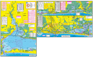
This is a two-sided inshore saltwater fishing map of the coastal areas surrounding Freeport. Included on the map are West Bay, Chocolate Bay, Christmas Bay, Bastrop Bay, Cedar Lakes, and the east end of East Matagorda Bay. This map offers many very good out of the way spots that are seldom fished. The map has GPS numbers for fishing spots, marinas, boat ramps, and other locations.
Maps include freshwater, inshore saltwater, & offshore saltwater areas. Defines dozens of well-marked fishing spots. Important information, such as types of fish caught, best fishing months of the year, & underwater structure is shown on the map in an easy-to-read format. In addition, detailed information is also provided for boat ramps, bait camps, & marinas. Waterproof paper. Most maps now have GPS coordinates for fishing locations, boat ramps, marinas, & other points of interest.
Reviews
There are no reviews yet.